
Make a donation
Gear up for your next adventure:
As an Amazon Associate, this site earns from qualifying purchases at no extra cost to you.
Monchique topographic map
Click on the map to display elevation.
Make a donation
Gear up for your next adventure:
As an Amazon Associate, this site earns from qualifying purchases at no extra cost to you.
Monchique
Monchique has a Mediterranean climate with warm to hot summers and mild, wet winters. Due to its altitude and location, right between the valley formed by the Serra de Monchique, precipitation in the winter is much larger than anywhere else on the Algarve. Its position on the southwest corner of Portugal gives it very mild temperatures in the winter, especially for its altitude.
Make a donation
Gear up for your next adventure:
As an Amazon Associate, this site earns from qualifying purchases at no extra cost to you.
About this map
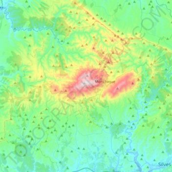
Name: Monchique topographic map, elevation, terrain.
Location: Monchique, Faro, Portugal (37.20982 -8.75513 37.41198 -8.41998)
Average elevation: 206 m
Minimum elevation: -2 m
Maximum elevation: 894 m
Make a donation
Gear up for your next adventure:
As an Amazon Associate, this site earns from qualifying purchases at no extra cost to you.
Other topographic maps
Click on a map to view its topography, its elevation and its terrain.
Make a donation
Gear up for your next adventure:
As an Amazon Associate, this site earns from qualifying purchases at no extra cost to you.
Algarve
The Algarve is located in the southernmost area of continental Portugal and the southwesternmost area of the Iberian Peninsula and mainland Europe, covering an area of 4,997 km2 (1,929 sq mi). It borders to the north with the Alentejo region (Alentejo Litoral and Baixo Alentejo), to the south and west with the…
Average elevation: 72 m
Make a donation
Gear up for your next adventure:
As an Amazon Associate, this site earns from qualifying purchases at no extra cost to you.
Make a donation
Gear up for your next adventure:
As an Amazon Associate, this site earns from qualifying purchases at no extra cost to you.
Make a donation
Gear up for your next adventure:
As an Amazon Associate, this site earns from qualifying purchases at no extra cost to you.
Make a donation
Gear up for your next adventure:
As an Amazon Associate, this site earns from qualifying purchases at no extra cost to you.
Make a donation
Gear up for your next adventure:
As an Amazon Associate, this site earns from qualifying purchases at no extra cost to you.
Make a donation
Gear up for your next adventure:
As an Amazon Associate, this site earns from qualifying purchases at no extra cost to you.
Make a donation
Gear up for your next adventure:
As an Amazon Associate, this site earns from qualifying purchases at no extra cost to you.
São Brás de Alportel
Portugal > Faro > São Brás de Alportel > São Brás de Alportel
Average elevation: 254 m
Make a donation
Gear up for your next adventure:
As an Amazon Associate, this site earns from qualifying purchases at no extra cost to you.
Make a donation
Gear up for your next adventure:
As an Amazon Associate, this site earns from qualifying purchases at no extra cost to you.
Make a donation
Gear up for your next adventure:
As an Amazon Associate, this site earns from qualifying purchases at no extra cost to you.
Juncais
Portugal > Faro > São Brás de Alportel > São Brás de Alportel > Juncais
Average elevation: 310 m
Belo Romão
Portugal > Faro > Moncarapacho e Fuseta > Moncarapacho > Belo Romão
Average elevation: 27 m
Make a donation
Gear up for your next adventure:
As an Amazon Associate, this site earns from qualifying purchases at no extra cost to you.