
Ziro topographic map
Interactive map
Click on the map to display elevation.
Ziro
Ziro is the district headquarter of Lower Subansiri district and is one of the oldest towns in Arunachal Pradesh. It is located at 27°38′N 93°50′E / 27.63°N 93.83°E / 27.63; 93.83 at an elevation of 1688 metres (5538 feet) to 2438 meters (8000 feet). Its cool weather in summer is its major attraction. It is famous for its surrounding pine-clad gentle hills and its rice fields. Ziro is home to the Apatani tribe.
About this map
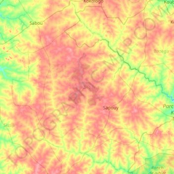
Name: Ziro topographic map, elevation, terrain.
Location: Ziro, Central-West, Burkina Faso (11.34254 -2.37409 12.00728 -1.30960)
Average elevation: 319 m
Minimum elevation: 266 m
Maximum elevation: 389 m
Other topographic maps
Click on a map to view its topography, its elevation and its terrain.