
Rutland County topographic map
Interactive map
Click on the map to display elevation.
About this map
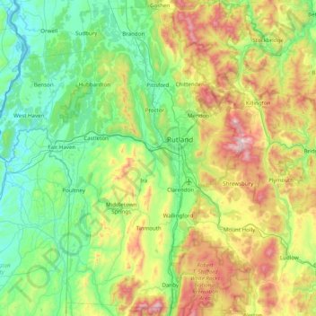
Name: Rutland County topographic map, elevation, terrain.
Location: Rutland County, Vermont, United States (43.29055 -73.43139 43.85806 -72.69980)
Average elevation: 367 m
Minimum elevation: 25 m
Maximum elevation: 1,258 m
Other topographic maps
Click on a map to view its topography, its elevation and its terrain.
Mount Mansfield
United States > Vermont > Chittenden County > Underhill
Mount Mansfield is the highest mountain in Vermont, reaching an elevation of 4,393 feet (1,339 m) above sea level. Located in the northwest of the state, it is also the highest peak in the Green Mountains. Its summit is located within the town of Underhill in Chittenden County; the ridgeline, including some…
Average elevation: 914 m
Topsham Four Corners
United States > Vermont > Orange County > Topsham > Topsham
Average elevation: 346 m