Geolocate

The Alps topographic map

Click on the map to display elevation.

About this map

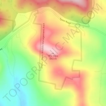
Name: The Alps topographic map, elevation, terrain.

Location: The Alps, Reading, Windsor County, Vermont, United States (43.47502 -72.63820 43.47512 -72.63810)

Average elevation: 551 m

Minimum elevation: 419 m

Maximum elevation: 670 m

Gear up for your next adventure:

🚲Heavy Duty Bike Lock - Secure your bike at the trailhead or during stops
🧢Sun Protection Cap - Breathable cap to protect from sun exposure
🧊Portable Cooler - Keep food and drinks cold during outdoor adventures
🚲Handlebar Phone Mount - View topographic-map.com live while cycling
🧰Multitool Knife - Compact and versatile tool for outdoor use

As an Amazon Associate, this site earns from qualifying purchases at no extra cost to you.