
Make a donation
Gear up for your next adventure:
As an Amazon Associate, this site earns from qualifying purchases at no extra cost to you.
Daglan topographic map
Click on the map to display elevation.
Gear up for your next adventure:
As an Amazon Associate, this site earns from qualifying purchases at no extra cost to you.
About this map
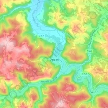
Name: Daglan topographic map, elevation, terrain.
Average elevation: 178 m
Minimum elevation: 83 m
Maximum elevation: 286 m
Make a donation
Gear up for your next adventure:
As an Amazon Associate, this site earns from qualifying purchases at no extra cost to you.
Other topographic maps
Click on a map to view its topography, its elevation and its terrain.
Les Garrières
France > Nouvelle-Aquitaine > Dordogne > Saint-Saud-Lacoussière
Average elevation: 293 m
Make a donation
Gear up for your next adventure:
As an Amazon Associate, this site earns from qualifying purchases at no extra cost to you.
Make a donation
Gear up for your next adventure:
As an Amazon Associate, this site earns from qualifying purchases at no extra cost to you.
Le Clau du Bois
France > Nouvelle-Aquitaine > Dordogne > Saint-Romain-et-Saint-Clément
Average elevation: 221 m
La Croix de Ruchal
France > Nouvelle-Aquitaine > Dordogne > Rouffignac-Saint-Cernin-de-Reilhac
Average elevation: 239 m
Make a donation
Gear up for your next adventure:
As an Amazon Associate, this site earns from qualifying purchases at no extra cost to you.
Make a donation
Gear up for your next adventure:
As an Amazon Associate, this site earns from qualifying purchases at no extra cost to you.
Château de Castelnaud-la-Chapelle
France > Nouvelle-Aquitaine > Dordogne > Castelnaud-la-Chapelle > Castelnaud
Average elevation: 146 m
Make a donation
Gear up for your next adventure:
As an Amazon Associate, this site earns from qualifying purchases at no extra cost to you.
Make a donation
Gear up for your next adventure:
As an Amazon Associate, this site earns from qualifying purchases at no extra cost to you.