
New Britain topographic map
Interactive map
Click on the map to display elevation.
New Britain
The island is part of two ecoregions. The New Britain-New Ireland lowland rain forests extend from sea level to 1000 meters elevation. The New Britain-New Ireland montane rain forests cover the mountains of New Britain above 1000 meters elevation.
About this map
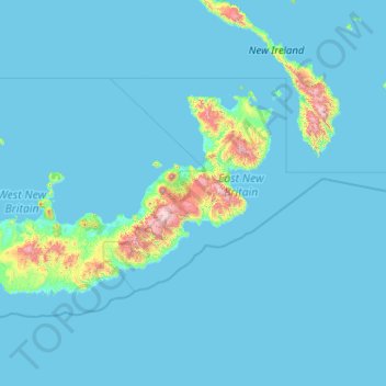
Name: New Britain topographic map, elevation, terrain.
Location: New Britain, Islands Region, Papua New Guinea (-6.31595 148.30788 -4.13316 152.40407)
Average elevation: 77 m
Minimum elevation: 0 m
Maximum elevation: 2,268 m
Other topographic maps
Click on a map to view its topography, its elevation and its terrain.
Port Moresby
Papua New Guinea > National Capital District > National Capital District
Average elevation: 34 m