Buren topographic map
Interactive map
Click on the map to display elevation.
About this map
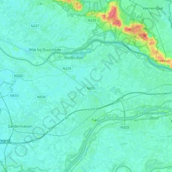
Name: Buren topographic map, elevation, terrain.
Location: Buren, Gelderland, Netherlands (51.87340 5.24192 51.98595 5.58662)
Average elevation: 5 m
Minimum elevation: -2 m
Maximum elevation: 72 m
Other topographic maps
Click on a map to view its topography, its elevation and its terrain.
Oud-Zevenaar
Netherlands > Gelderland > Zevenaar
Oud-Zevenaar, Zevenaar, Gelderland, Netherlands, 6905 AJ, Netherlands
Average elevation: 12 m
Wageningen
Netherlands > Gelderland > Wageningen
Wageningen, Gelderland, Netherlands
Average elevation: 14 m
Apeldoorn
Netherlands > Gelderland > Apeldoorn
Apeldoorn, Gelderland, Netherlands
Average elevation: 23 m
Rozendaal
Netherlands > Gelderland > Rozendaal
Rozendaal, Gelderland, Netherlands
Average elevation: 66 m