
Kasai topographic map
Interactive map
Click on the map to display elevation.
About this map
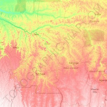
Name: Kasai topographic map, elevation, terrain.
Location: Kasai, Democratic Republic of the Congo (-7.94980 18.82410 -2.74980 24.02410)
Average elevation: 609 m
Minimum elevation: 305 m
Maximum elevation: 1,143 m
Other topographic maps
Click on a map to view its topography, its elevation and its terrain.
Uhuru
Democratic Republic of the Congo > Haut-Katanga > Ville de Lubumbashi > Upemba
Average elevation: 1,214 m
Katuba
Democratic Republic of the Congo > Haut-Katanga > Ville de Lubumbashi
Average elevation: 1,206 m
Goma
Democratic Republic of the Congo > North Kivu
The name Goma derived from a modification of ngoma, the city's former designation, a term of profound cultural and linguistic relevance among Bantu-speaking communities throughout Central, Southern, and East Africa. Ngoma is translated as "drum", and is commonly associated with ritual dances and ceremonies in…
Average elevation: 1,613 m
Congo
Democratic Republic of the Congo
The Congo basin covers ten countries and accounts for about 13% of Africa. The highest point in the Congo basin is in the Ruwenzori Mountains, at an altitude of around 4,340 m (14,240 ft) above sea level.
Average elevation: 482 m
Marungu
Democratic Republic of the Congo > Haut-Katanga > Ville de Lubumbashi > Kisale
Average elevation: 1,204 m
Lubumbashi
Democratic Republic of the Congo > Haut-Katanga > Ville de Lubumbashi
Lubumbashi lies at around 1,208 m (3,963 ft) above sea level. The high altitude serves to cool the climate, which would otherwise be very hot. The Kafue River rises along the Zambian border near the city and meanders through north-central Zambia to the Zambezi River, cutting a long, deep panhandle into the…
Average elevation: 1,249 m
N'djili
Democratic Republic of the Congo > Kinshasa
The river catchment has sandy soils and steep topography, as with other rivers that supply the city. With clearing of the forests, there has been growing soil erosion, leading to sediment pollution. When turbidity levels rise above the 1,000 NTU limit, which has often been reported in the Ndjili and Lukaya…
Average elevation: 362 m
Mount Stanely
Democratic Republic of the Congo > North Kivu > Beni
Mount Stanley, also known as Mount Ngaliema (/əŋɡɑːˈljeɪmə/, also US: /-mɑː/, UK: /əŋˌɡɑːliˈeɪmə/), is a mountain located in the Rwenzori range. With an elevation of 5,109 m (16,763 ft), it is the highest mountain of both the Democratic Republic of the Congo and Uganda, and the third highest…
Average elevation: 4,174 m
Bukavu
Democratic Republic of the Congo > South Kivu
Köppen-Geiger climate classification system classifies Bukavu's climate as tropical savanna (Aw), although it is milder than most climates of its type due to high altitude. Bukavu sees very warm days and pleasant nights year round.
Average elevation: 1,654 m
Goma
Democratic Republic of the Congo > North Kivu
Köppen-Geiger climate classification system classifies Goma's climate as a tropical savanna climate (Aw). Goma is much milder than most climates of its latitude due to the city's high altitude, and sees warm days and pleasant nights year-round.
Average elevation: 1,613 m
Bukavu
Democratic Republic of the Congo > South Kivu
Köppen-Geiger climate classification system classifies Bukavu's climate as tropical savanna (Aw), although it is milder than most climates of its type due to high altitude. Bukavu sees very warm days and pleasant nights year round.
Average elevation: 1,654 m
Munua
Democratic Republic of the Congo > Haut-Katanga > Ville de Lubumbashi
Average elevation: 1,271 m
Kinshasa
Democratic Republic of the Congo
Covering 9,965 square kilometers, Kinshasa stretches along the southern shores of the Pool Malebo, on the Congo River. It forms an expansive crescent across flat, low-lying terrain at an average altitude of about 300 meters. Situated between latitudes 4° and 5° and longitudes East 15° and 16°32, Kinshasa…
Average elevation: 515 m
Bukavu
Democratic Republic of the Congo > South Kivu
Köppen-Geiger climate classification system classifies Bukavu's climate as tropical savanna (Aw), although it is milder than most climates of its type due to high altitude. Bukavu sees very warm days and pleasant nights year round.
Average elevation: 1,654 m
Quebec
Democratic Republic of the Congo > Haut-Katanga > Ville de Lubumbashi > Lubumbashi
Average elevation: 1,219 m
Bunia
Democratic Republic of the Congo > Ituri
It lies at an elevation of 1,275 metres or 4,180 feet on a plateau about 30 kilometres or 19 miles west of Lake Albert in the Albertine Rift, and about 25 kilometres or 16 miles east of the Ituri Rainforest.
Average elevation: 1,273 m
Bunia
Democratic Republic of the Congo > Ituri
It lies at an elevation of 1,275 metres or 4,180 feet on a plateau about 30 kilometres or 19 miles west of Lake Albert in the Albertine Rift, and about 25 kilometres or 16 miles east of the Ituri Rainforest.
Average elevation: 1,273 m