
Gracias a Dios topographic map
Interactive map
Click on the map to display elevation.
About this map
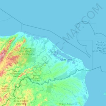
Name: Gracias a Dios topographic map, elevation, terrain.
Location: Gracias a Dios, Honduras (14.61585 -85.00074 16.25108 -82.18164)
Average elevation: 81 m
Minimum elevation: -2 m
Maximum elevation: 1,770 m
Other topographic maps
Click on a map to view its topography, its elevation and its terrain.
Tegucigalpa
Honduras > Francisco Morazán > Tegucigalpa
Tegucigalpa is located on a chain of mountains with elevations of 975 metres (3,199 ft) at its lowest points and 1,463 metres (4,800 ft) at its highest suburban areas. Like most of the interior highlands of Honduras, the majority of Tegucigalpa's current area was occupied by open woodland. The area surrounding…
Average elevation: 1,281 m