
Penafiel topographic map
Interactive map
Click on the map to display elevation.
Penafiel
Arrifana de Sousa continued to grow as a centre of services and industry, supported by an annual fair on the feast day of São Martinho, resulting in the expansion of the urban environment to the upper elevations and the construction of the Church of the Misericórdia. Meanwhile, the nobles established their homes outside the town centre, preferring to live in their ancestral estates, established from the land rents and businesses and overseas commerce.
About this map
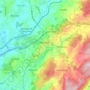
Name: Penafiel topographic map, elevation, terrain.
Location: Penafiel, Porto, Tâmega e Sousa, North, Portugal (41.17446 -8.31854 41.23445 -8.23213)
Average elevation: 276 m
Minimum elevation: 127 m
Maximum elevation: 532 m