
Kanchipuram topographic map
Interactive map
Click on the map to display elevation.
Kanchipuram
Kanchipuram is located at 12°59′N 79°43′E / 12.98°N 79.71°E / 12.98; 79.71, 72 km (45 mi) south-west of Chennai on the banks of the Vegavathi River, a tributary of the Palar River. The city covers an area of 11.6 km2 (4.5 sq mi) and has an elevation of 83.2 m (273 ft) above sea level.The land around Kanchipuram is flat and slopes towards the south and east. The soil in the region is mostly clay, with some loam, clay, and sand, which are suitable for use in construction. The Chingleput District Manual (1879) describes the region's soils as "highly inferior" and "highly stony or mixed with lime, gravel, soda and laterite". It has been postulated that the granite required for the Varadaraja Perumal Temple might have been obtained from the Sivaram Hills located 10 miles east of Kanchipuram. The area is classified as a Seismic Zone II region, and earthquakes of up to magnitude 6 on the Richter Scale may be expected. Kanchipuram is subdivided into two divisions – Big Kanchi, also called Shiva Kanchi occupies the western portion of the city and is the larger of the two divisions. Little Kanchi, also called Vishnu Kanchi, is located on the eastern fringes of the city. Most of the Shiva temples lie in Big Kanchi while most of the Vishnu temples lie in Little Kanchi.
About this map
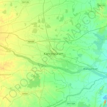
Name: Kanchipuram topographic map, elevation, terrain.
Average elevation: 82 m
Minimum elevation: 43 m
Maximum elevation: 187 m
Other topographic maps
Click on a map to view its topography, its elevation and its terrain.
Thiruvilliputtur state assembly constituency
India > Tamil Nadu > Srivilliputhur
Average elevation: 321 m
Ramanathapuram
India > Tamil Nadu > Ramanathapuram
Ramanathapuram is located at 9°23′N 78°50′E / 9.38°N 78.83°E / 9.38; 78.83. It has an average elevation of 2 metres (6 feet). The nearest towns include Paramakudi, Rameshwaram, Mudukulathur, Kilakarai and Manamadurai.
Average elevation: 7 m
Vellore
Yelagiri is a hill station located in Tirupattur district of the Vaniyambadi-Tirupattur road at an altitude of 1,410.6 metres above mean sea level and spread across 30 km2.
Average elevation: 349 m
Kovilpatti
India > Tamil Nadu > Kovilpatti
Kovilpatti is located at 9°10′N 77°52′E / 9.17°N 77.87°E / 9.17; 77.87. It has an average elevation of 106 metres (347 feet). Located 100 km south of Madurai, 55 km north of Tirunelveli and 60 km north-west of Tuticorin, Kovilpatti is situated on National Highway No. 07 NH 7, which connects…
Average elevation: 97 m
Tiruvannamalai
India > Tamil Nadu > Tiruvannamalai
Tiruvannamalai is situated 196 km (122 mi) from the state capital Chennai and 210 km (130 mi) from Bangalore. The height of the Annamalai hill is approximately 2,669 ft (814 m). Tiruvannamalai is located at 12°00′N 79°03′E / 12°N 79.05°E / 12; 79.05. It has an average elevation of 200 metres…
Average elevation: 202 m
St.Thomas Mount-Pallavaram Cantonment Board
India > Tamil Nadu > Alandur > St.Thomas Mount-Pallavaram Cantonment Board
Average elevation: 13 m
Thiruvallur District
The northern taluks of the district like Ponneri, Uttukkottai, Gummidipundi etc. do not have much to offer from the scenic point of view. In the Tiruttani taluk, a number of hillocks are found scattered. The soil of the district is mostly sandy, mixed with soda or other alkali or stony. Rocks found in and near…
Average elevation: 50 m
Tiruchirappalli
India > Tamil Nadu > Tiruchchirāppalli
Tiruchirappalli is situated in central south-eastern India, almost at the geographic centre of the state of Tamil Nadu. The Cauvery Delta begins to form 16 kilometres (9.9 mi) west of the city where the river divides into two streams—the Kaveri and the Kollidam—to form the island of Srirangam. By road it…
Average elevation: 78 m
Chennai
India > Tamil Nadu > Chennai
Chennai is located on the south–eastern coast of India in the north–eastern part of Tamil Nadu on a flat coastal plain known as the Eastern Coastal Plains. Its average elevation is around 6.7 metres (22 ft), and its highest point is 60 m (200 ft). Chennai is 2,184 kilometres (1,357 mi) south of Delhi,…
Average elevation: 7 m
Madurai
India > Tamil Nadu > Madurai South
Madurai is located at 9°56′N 78°07′E / 9.93°N 78.12°E / 9.93; 78.12. It has an average elevation of 134 metres. The city of Madurai lies on the flat and fertile plain of the river Vaigai, which runs in the northwest–southeast direction through the city, dividing it into two almost equal…
Average elevation: 137 m
Dharapuram
India > Tamil Nadu > Dharapuram
Dharapuram is located at 10°44′N 77°31′E / 10.73°N 77.52°E / 10.73; 77.52. Dharapuram town is situated along of the bank of Amaravathi River which flows from the south to north. Uppar River and dam, Nallathankal River and dam, Palar join the river Amaravathi. It has an average elevation of 245…
Average elevation: 252 m