
Detroit topographic map
Interactive map
Click on the map to display elevation.
About this map
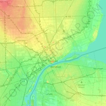
Name: Detroit topographic map, elevation, terrain.
Location: Detroit, Wayne County, Michigan, United States (42.25519 -83.28796 42.45040 -82.91044)
Average elevation: 187 m
Minimum elevation: 169 m
Maximum elevation: 217 m
The city slopes gently from the northwest to southeast on a till plain composed largely of glacial and lake clay. The most notable topographical feature in the city is the Detroit Moraine, a broad clay ridge on which the older portions of Detroit and Windsor are located, rising approximately 62 feet (19 m) above the river at its highest point.[103] The highest elevation in the city is directly north of Gorham Playground on the northwest side approximately three blocks south of 8 Mile Road, at a height of 675 to 680 feet (206 to 207 m).[104] Detroit's lowest elevation is along the Detroit River, at a surface height of 572 feet (174 m).[105]
Other topographic maps
Click on a map to view its topography, its elevation and its terrain.
Northville
United States > Michigan > Wayne County
Northville, Wayne County, Michigan, United States
Average elevation: 258 m
Brownstown Charter Township
United States > Michigan > Wayne County
Brownstown Charter Township, Wayne County, Michigan, 48134, United States
Average elevation: 183 m
Northville Township
United States > Michigan > Wayne County
Northville Township, Wayne County, Michigan, United States
Average elevation: 260 m
Grosse Ile Township
United States > Michigan > Wayne County
Grosse Ile Township, Wayne County, Michigan, 48138, United States
Average elevation: 179 m
Canton
United States > Michigan > Wayne County > Canton
Canton, Wayne County, Michigan, United States
Average elevation: 214 m
Lincoln Park
United States > Michigan > Wayne County > Lincoln Park
Lincoln Park, Wayne County, Michigan, 48146, United States
Average elevation: 180 m
Belle Isle
United States > Michigan > Wayne County > Detroit
Belle Isle, Detroit, Wayne County, Michigan, 48207, United States
Average elevation: 177 m
Plymouth
United States > Michigan > Wayne County
Plymouth, Wayne County, Michigan, United States
Average elevation: 223 m
Rockwood
United States > Michigan > Wayne County
Rockwood, Wayne County, Michigan, United States
Average elevation: 178 m
Livonia
United States > Michigan > Wayne County
Livonia, Wayne County, Michigan, United States
Average elevation: 201 m