
Trinity County topographic map
Interactive map
Click on the map to display elevation.
About this map
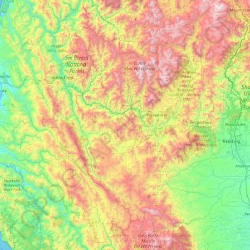
Name: Trinity County topographic map, elevation, terrain.
Location: Trinity County, California, United States (39.97696 -123.62377 41.36855 -122.44580)
Average elevation: 868 m
Minimum elevation: 0 m
Maximum elevation: 2,663 m
The county hosts many visitors, especially during summer months, for camping, backpacking, boating on the lakes, rafting/kayaking on the rivers, hunting, and fishing. The summers tend to be clear, sunny, warm, and very dry, with little rain from June to September except for some mountain thunderstorms in the highest elevations. Summer days in the populated areas of the county range from 90 to 97 degrees, and summer nights range from 45 to 55. Winter days range from 40 to 50, and nights range from 25 to 35. The winters tend to have copious precipitation, increasing with elevation and falling mostly as rain under 1000m/3300 ft in the valley bottoms, and mostly as snow over 1000m/3300 ft on the mountainsides. December, January, and February are the wettest. The precipitation ranges from 30 to 35 inches at low elevations isolated from coastal influence, such as Big Bar, Hayfork, and Weaverville, up to 55 or 60 inches at high elevations, on the coastal side of South Fork Mountain, or where gaps in the mountain allow for precipitation to get through. Examples of this last phenomenon include Salyer and Forest Glen. Kalmia Lake, at nearly 7500 feet in the Canyon Creek area of the Trinity Alps, is reputed to be the snowiest place in California, outpacing Lake Helen in Mount Lassen National Park, which receives 600-700 inches of snow each winter. Average snowfall in the populated parts of the county ranges from 0-5 inches in the lower Trinity Valley to at least 100 inches in places above 4000 feet, such as Indian Valley west of Hayfork.
Other topographic maps
Click on a map to view its topography, its elevation and its terrain.
Weaverville
United States > California > Trinity County
Weaverville, Trinity County, California, United States
Average elevation: 972 m