
Make a donation
Gear up for your next adventure:
As an Amazon Associate, this site earns from qualifying purchases at no extra cost to you.
Weaverville topographic map
Click on the map to display elevation.
Make a donation
Gear up for your next adventure:
As an Amazon Associate, this site earns from qualifying purchases at no extra cost to you.
About this map
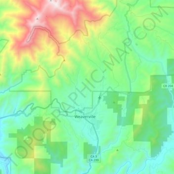
Name: Weaverville topographic map, elevation, terrain.
Location: Weaverville, Trinity County, California, United States (40.68097 -123.00487 40.83177 -122.88697)
Average elevation: 972 m
Minimum elevation: 455 m
Maximum elevation: 2,331 m
Make a donation
Gear up for your next adventure:
As an Amazon Associate, this site earns from qualifying purchases at no extra cost to you.
Other topographic maps
Click on a map to view its topography, its elevation and its terrain.
Hayfork
United States > California > Trinity County
Hayfork is located at 40°34′17″N 123°8′48″W / 40.57139°N 123.14667°W / 40.57139; -123.14667 (40.571406, -123.146619) at an elevation of 2310 feet.
Average elevation: 1,049 m