
Elkwater topographic map
Interactive map
Click on the map to display elevation.
About this map
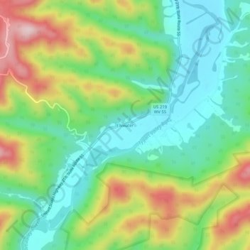
Name: Elkwater topographic map, elevation, terrain.
Location: Elkwater, Randolph County, West Virginia, United States (38.61650 -80.03535 38.65650 -79.99535)
Average elevation: 747 m
Minimum elevation: 630 m
Maximum elevation: 952 m
Other topographic maps
Click on a map to view its topography, its elevation and its terrain.
Shavers Fork
United States > West Virginia > Randolph County
Shavers Fork rises in north-central Pocahontas County at Thorny Flat, highest peak of Cheat Mountain (4,848 ft; 1,478 m) and the site of Snowshoe Mountain ski resort. Its headwaters flow through the ghost town of Spruce. The river then flows generally north-northeastwardly through Randolph and Tucker Counties,…
Average elevation: 884 m