
Shavers Fork topographic map
Interactive map
Click on the map to display elevation.
Shavers Fork
Shavers Fork rises in north-central Pocahontas County at Thorny Flat, highest peak of Cheat Mountain (4,848 ft; 1,478 m) and the site of Snowshoe Mountain ski resort. Its headwaters flow through the ghost town of Spruce. The river then flows generally north-northeastwardly through Randolph and Tucker Counties, where its valley is the trough between Cheat Mountain (to the west) and Shavers Mountain (to the east). Settlements along its course include Cheat Bridge, Bemis, Bowden, and Porterwood. The "High Falls of Cheat" (15 feet [4.6 m] high) is a few miles upstream of Bemis. Shavers Fork ultimately joins the Black Fork at Parsons to form the Cheat at an elevation of 1,621 ft (494 m).
About this map
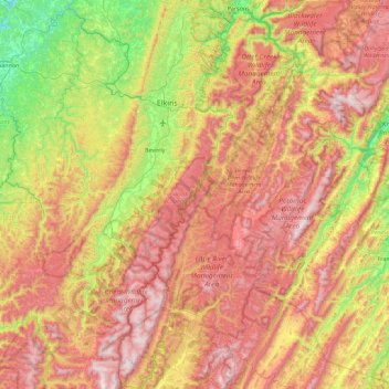
Name: Shavers Fork topographic map, elevation, terrain.
Location: Shavers Fork, Randolph County, West Virginia, United States (38.40451 -79.98437 39.11121 -79.67685)
Average elevation: 884 m
Minimum elevation: 359 m
Maximum elevation: 1,469 m
Other topographic maps
Click on a map to view its topography, its elevation and its terrain.