
Mahasamund topographic map
Interactive map
Click on the map to display elevation.
About this map
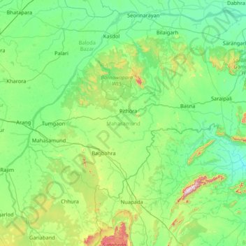
Name: Mahasamund topographic map, elevation, terrain.
Location: Mahasamund, Chhattisgarh, Inde (20.82806 81.98835 21.55676 83.27851)
Average elevation: 299 m
Minimum elevation: 176 m
Maximum elevation: 1,000 m
Other topographic maps
Click on a map to view its topography, its elevation and its terrain.
Jashpur Tahsil
Jashpur Tahsil, Jashpur District, Chhattisgarh, Inde
Average elevation: 712 m
Nava Raipur Atal Nagar
Inde > Chhattisgarh > Nava Raipur Atal Nagar
Nava Raipur Atal Nagar, Arang Tahsil, Raipur, Chhattisgarh, Inde
Average elevation: 305 m
Kanker
Inde > Chhattisgarh > Kanker
Kanker, Kanker Tahsil, Uttar Bastar Kanker, Chhattisgarh, 494334, Inde
Average elevation: 405 m
Bilaspur
Inde > Chhattisgarh > Bilaspur
Bilaspur, Bilāspur, Bilaspur, Chhattisgarh, 495004, Inde
Average elevation: 270 m