
Jashpur topographic map
Interactive map
Click on the map to display elevation.
About this map
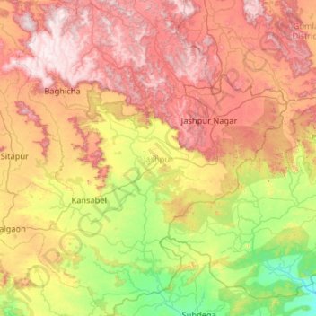
Name: Jashpur topographic map, elevation, terrain.
Location: Jashpur, Chhattisgarh, Inde (22.28818 83.38676 23.24457 84.39596)
Average elevation: 603 m
Minimum elevation: 215 m
Maximum elevation: 1,150 m
Other topographic maps
Click on a map to view its topography, its elevation and its terrain.
Jashpur Tahsil
Jashpur Tahsil, Jashpur District, Chhattisgarh, Inde
Average elevation: 712 m
Nava Raipur Atal Nagar
Inde > Chhattisgarh > Nava Raipur Atal Nagar
Nava Raipur Atal Nagar, Arang Tahsil, Raipur, Chhattisgarh, Inde
Average elevation: 305 m
Kanker
Inde > Chhattisgarh > Kanker
Kanker, Kanker Tahsil, Uttar Bastar Kanker, Chhattisgarh, 494334, Inde
Average elevation: 405 m
Bilaspur
Inde > Chhattisgarh > Bilaspur
Bilaspur, Bilāspur, Bilaspur, Chhattisgarh, 495004, Inde
Average elevation: 270 m