Geolocate

Fairholme topographic map

Interactive map

Click on the map to display elevation.

About this map

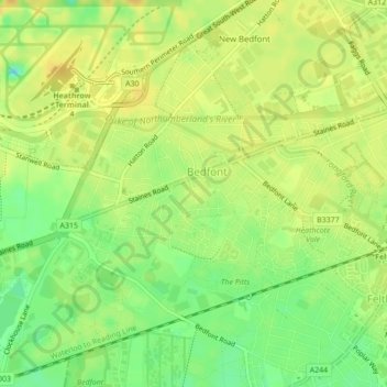
Name: Fairholme topographic map, elevation, terrain.

Location: Fairholme, East Bedfont, Bedfont, London Borough of Hounslow, London, Greater London, England, United Kingdom (51.45107 -0.43341 51.45207 -0.43134)

Average elevation: 20 m

Minimum elevation: 3 m

Maximum elevation: 31 m

Other topographic maps

Click on a map to view its topography, its elevation and its terrain.

London

United Kingdom > England > London

Average elevation: 42 m

Whitehall

United Kingdom > England > London

Average elevation: 16 m

Bromley

United Kingdom > England > London

Average elevation: 62 m

Orpington

United Kingdom > England > London

Average elevation: 88 m

Victoria Park

United Kingdom > England > London

Average elevation: 13 m

Croydon

United Kingdom > England > London > Croydon

Topographically, central Croydon generally lies between 50 metres (160 ft) (in the north) and 70 metres (230 ft) (in the south) above sea level. Elevation significantly climbs towards the east of the town - Coombe Park peaks at about 95 metres (312 ft) above sea level, whereas the Addington Hills, Coombe Wood…

Average elevation: 70 m

Greenwich

United Kingdom > England > London

Average elevation: 20 m

Wimbledon

United Kingdom > England > London > Wimbledon

Average elevation: 26 m

Walthamstow Wetlands

United Kingdom > England > London

Average elevation: 12 m

Hampstead

United Kingdom > England > London

Average elevation: 57 m