
Thorold topographic map
Interactive map
Click on the map to display elevation.
About this map
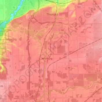
Name: Thorold topographic map, elevation, terrain.
Location: Thorold, Niagara Region, Golden Horseshoe, Ontario, Canada (43.02669 -79.28716 43.14060 -79.16858)
Average elevation: 175 m
Minimum elevation: 84 m
Maximum elevation: 221 m
Niagara Region trails, hiking, mountain biking, running and outdoor activities
Other topographic maps
Click on a map to view its topography, its elevation and its terrain.
Queenston Heights Park
Canada > Ontario > Niagara Region > Niagara-on-the-Lake > Queenston
Average elevation: 139 m