
Make a donation
Gear up for your next adventure:
As an Amazon Associate, this site earns from qualifying purchases at no extra cost to you.
Ammelsdorf topographic map
Click on the map to display elevation.
Make a donation
Gear up for your next adventure:
As an Amazon Associate, this site earns from qualifying purchases at no extra cost to you.
About this map
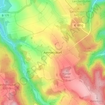
Name: Ammelsdorf topographic map, elevation, terrain.
Average elevation: 625 m
Minimum elevation: 516 m
Maximum elevation: 720 m
Make a donation
Gear up for your next adventure:
As an Amazon Associate, this site earns from qualifying purchases at no extra cost to you.
Other topographic maps
Click on a map to view its topography, its elevation and its terrain.
Dippoldiswalde
Deutschland > Sachsen > Sächsische Schweiz-Osterzgebirge > Dippoldiswalde
Average elevation: 446 m
Talsperre Malter
Deutschland > Sachsen > Sächsische Schweiz-Osterzgebirge > Dippoldiswalde > Malter
Average elevation: 368 m
01744
Deutschland > Sachsen > Sächsische Schweiz-Osterzgebirge > Dippoldiswalde
Average elevation: 498 m