Geolocate

Sishui County topographic map

Click on the map to display elevation.

About this map

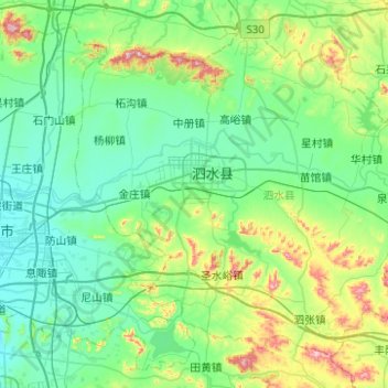
Name: Sishui County topographic map, elevation, terrain.

Location: Sishui County, Jining, Shandong, China (35.46330 117.09215 35.80133 117.58887)

Average elevation: 160 m

Minimum elevation: 62 m

Maximum elevation: 563 m

Gear up for your next adventure:

🥾Hiking Leggings - Comfortable leggings for outdoor activities
🦟Insect Repellent - Keep mosquitoes and black flies away in wooded areas
🥾Light Hiking Boots - Lightweight and comfortable boots for day hikes
🧭GPS Tracker - Track your location in remote areas safely
🥾Waterproof Hiking Boots - Boots keeping your feet dry in wet conditions

As an Amazon Associate, this site earns from qualifying purchases at no extra cost to you.