Geolocate

Tiel topographic map

Click on the map to display elevation.

About this map

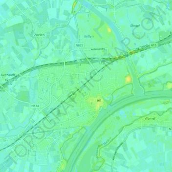
Name: Tiel topographic map, elevation, terrain.

Location: Tiel, Gelderland, Netherlands (51.86209 5.38322 51.92276 5.47245)

Average elevation: 6 m

Minimum elevation: 1 m

Maximum elevation: 17 m

Gear up for your next adventure:

🧼Travel Hand Sanitizer - Keep hands clean when water is scarce
🦟Insect Repellent - Keep mosquitoes and black flies away in wooded areas
🥾Trail Running Shoes - Lightweight and durable shoes for trail running
🧭Orienteering Kit - Tools for map reading and navigation in the wild
Camping Essentials - All-in-one gear for a comfortable camping trip

As an Amazon Associate, this site earns from qualifying purchases at no extra cost to you.