
Payyanur topographic map
Interactive map
Click on the map to display elevation.
About this map
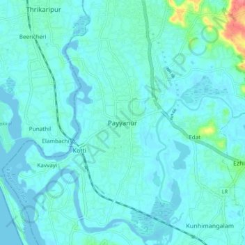
Name: Payyanur topographic map, elevation, terrain.
Average elevation: 8 m
Minimum elevation: -2 m
Maximum elevation: 66 m
Payyanur is located at coordinates 12°06′N 75°12′E / 12.1°N 75.2°E / 12.1; 75.2. It has an average elevation of 16 metres (51 feet).
Other topographic maps
Click on a map to view its topography, its elevation and its terrain.
Padiyottuchal
India > Kerala > Payyannur Taluk
Padiyottuchal, Payyannur Taluk, Kannur District, Kerala, 670353, India
Average elevation: 106 m
Vellur
India > Kerala > Payyannur Taluk
Vellur, Payyannur Taluk, Kannur District, Kerala, 670307, India
Average elevation: 11 m
Palakkunnu
India > Kerala > Payyannur Taluk
Palakkunnu, Payyannur Taluk, Kannur District, Kerala, 671310, India
Average elevation: 12 m
Payyannur Taluk
India > Kerala > Payyannur Taluk
Payyannur Taluk, Kannur district, Kerala, India
Average elevation: 62 m
Kalliasseri Block
India > Kerala > Payyannur Taluk
Kalliasseri Block, Payyannur Taluk, Kannur district, Kerala, India
Average elevation: 14 m