Geolocate

Dongxing topographic map

Click on the map to display elevation.

About this map

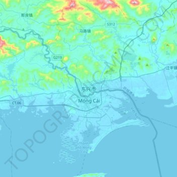
Name: Dongxing topographic map, elevation, terrain.

Location: Dongxing, Fangchenggang City, Guangxi, China (21.39064 107.80798 21.71064 108.12798)

Average elevation: 44 m

Minimum elevation: -3 m

Maximum elevation: 690 m

Gear up for your next adventure:

🧦Hiking Socks - Moisture-wicking and comfortable socks for long hikes
💡Compact LED Flashlight - Powerful and portable flashlight for outdoor use
🧴Bear Spray Holster - Quick-access carry for essential Canadian wilderness safety
🧢Sun Hat - Wide-brim hat for sun protection
🔦LED Headlamp - Hands-free lighting for early morning starts or late finishes

As an Amazon Associate, this site earns from qualifying purchases at no extra cost to you.