
Bislicher Insel topographic map
Interactive map
Click on the map to display elevation.
About this map
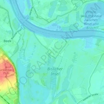
Name: Bislicher Insel topographic map, elevation, terrain.
Average elevation: 19 m
Minimum elevation: 9 m
Maximum elevation: 75 m
Other topographic maps
Click on a map to view its topography, its elevation and its terrain.
Wardt
Deutschland > Nordrhein-Westfalen > Kreis Wesel > Xanten
Wardt, Xanten, Kreis Wesel, Nordrhein-Westfalen, 46509, Deutschland
Average elevation: 17 m
Marienbaum
Deutschland > Nordrhein-Westfalen > Kreis Wesel > Xanten
Marienbaum, Xanten, Kreis Wesel, Nordrhein-Westfalen, Deutschland
Average elevation: 23 m
Vynen
Deutschland > Nordrhein-Westfalen > Kreis Wesel > Xanten
Vynen, Xanten, Kreis Wesel, Nordrhein-Westfalen, Deutschland
Average elevation: 17 m