
Richmond topographic map
Interactive map
Click on the map to display elevation.
About this map
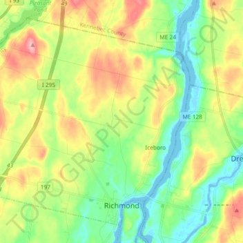
Name: Richmond topographic map, elevation, terrain.
Location: Richmond, Sagadahoc County, Maine, 04357, United States (44.07862 -69.90374 44.16810 -69.75800)
Average elevation: 46 m
Minimum elevation: -9 m
Maximum elevation: 119 m
Other topographic maps
Click on a map to view its topography, its elevation and its terrain.
Georgetown Island
United States > Maine > Sagadahoc County > Georgetown
Georgetown Island, Georgetown, Sagadahoc County, Maine, 04548, United States
Average elevation: 15 m
Woolwich
United States > Maine > Sagadahoc County
Woolwich, Sagadahoc County, Maine, 04579, United States
Average elevation: 21 m
Arrowsic
United States > Maine > Sagadahoc County
Arrowsic, Sagadahoc County, Maine, United States
Average elevation: 18 m
West Bath
United States > Maine > Sagadahoc County
West Bath, Sagadahoc County, Maine, United States
Average elevation: 15 m
Drummore Bay
United States > Maine > Sagadahoc County > Phippsburg
Drummore Bay, Phippsburg, Sagadahoc County, Maine, 04562, United States
Average elevation: 17 m
Bowdoinham
United States > Maine > Sagadahoc County
Bowdoinham, Sagadahoc County, Maine, 04008, United States
Average elevation: 44 m
Topsham
United States > Maine > Sagadahoc County
Topsham, Sagadahoc County, Maine, 04086, United States
Average elevation: 39 m
MacMahan Island
United States > Maine > Sagadahoc County > Georgetown
MacMahan Island, Georgetown, Sagadahoc County, Maine, United States
Average elevation: 8 m
Phippsburg
United States > Maine > Sagadahoc County
Phippsburg, Sagadahoc County, Maine, United States
Average elevation: 7 m
Georgetown
United States > Maine > Sagadahoc County
Georgetown, Sagadahoc County, Maine, 04548, United States
Average elevation: 8 m
Bath
United States > Maine > Sagadahoc County
Bath, Sagadahoc County, Maine, 04530, United States
Average elevation: 16 m