
Thank you for supporting this site ❤️
Make a donation
Make a donation
Gear up for your next adventure:
As an Amazon Associate, this site earns from qualifying purchases at no extra cost to you.
Arga topographic map
Click on the map to display elevation.
Thank you for supporting this site ❤️
Make a donation
Make a donation
Gear up for your next adventure:
As an Amazon Associate, this site earns from qualifying purchases at no extra cost to you.
About this map
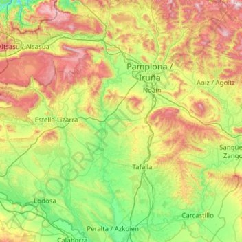
Name: Arga topographic map, elevation, terrain.
Location: Arga, Navarra, Espanha (42.29607 -1.85829 43.03487 -1.46372)
Average elevation: 584 m
Minimum elevation: 183 m
Maximum elevation: 1,515 m
Thank you for supporting this site ❤️
Make a donation
Make a donation
Gear up for your next adventure:
As an Amazon Associate, this site earns from qualifying purchases at no extra cost to you.
Other topographic maps
Click on a map to view its topography, its elevation and its terrain.
Hiru Erregeen Mahaia / Mesa de los Tres Reyes
Espanha > Navarra > Pirinioak / Pirineo > Isaba/Izaba
Average elevation: 2,028 m