Geolocate

Ladice topographic map

Click on the map to display elevation.

Ladice

The municipality lies at an altitude of 209 m (686 ft) and covers an area of 11.648 km2 (4.497 sq mi). It has a population of about 800 people.

Wikipedia (CC-BY-SA 3.0)

About this map

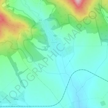
Name: Ladice topographic map, elevation, terrain.

Location: Ladice, District of Zlaté Moravce, Region of Nitra, Western Slovakia, 951 77, Slovakia (48.37335 18.24068 48.41131 18.29770)

Average elevation: 240 m

Minimum elevation: 177 m

Maximum elevation: 440 m

Gear up for your next adventure:

🧥Ultralight Puffy Jacket - Maximum warmth that packs down to the size of an orange
🛏️Sleeping Bag - Warm and compact sleeping bags for outdoor camping
🧭Orienteering Kit - Tools for map reading and navigation in the wild
🎒Hiking Backpack - Lightweight and ergonomic backpacks for day hikes or multi-day treks
🧥Thermal Fleece Jacket - Versatile insulation for changing mountain temperatures

As an Amazon Associate, this site earns from qualifying purchases at no extra cost to you.