
Oron topographic map
Interactive map
Click on the map to display elevation.
About this map
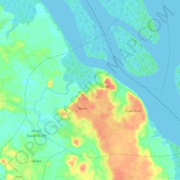
Name: Oron topographic map, elevation, terrain.
Location: Oron, Akwa Ibom, Nigeria (4.77558 8.19070 4.85409 8.29492)
Average elevation: 12 m
Minimum elevation: -1 m
Maximum elevation: 43 m
Other topographic maps
Click on a map to view its topography, its elevation and its terrain.
Ntuk Otong
Nigeria > Akwa Ibom > Ntuk Otong
Ntuk Otong, Ibesikpo Asutan, Akwa Ibom, Nigeria
Average elevation: 44 m
Okoko Item
Nigeria > Akwa Ibom > Okoko Item
Okoko Item, Obot Akara, Akwa Ibom, Nigeria
Average elevation: 78 m