
Make a donation
Gear up for your next adventure:
As an Amazon Associate, this site earns from qualifying purchases at no extra cost to you.
Kogelseespitze topographic map
Click on the map to display elevation.
Make a donation
Gear up for your next adventure:
As an Amazon Associate, this site earns from qualifying purchases at no extra cost to you.
Kogelseespitze
Die Kogelseespitze liegt zwischen dem Oberinntal im Südosten und dem Lechtal im Nordwesten. Benachbarte Berge sind im Norden, getrennt durch die Kogelseescharte (2497 m), die Bockkarspitzen (die Höchste 2602 m) und im Südosten, getrennt durch das Gufelseejoch (2281 m), die Parzinnspitze mit 2613 Metern Höhe. Nach Norden fällt das Gelände ab zum Kogelsee (Wasserspiegel auf 2171 m), nach Westen zum Otterbach, nach Osten zur Parzinnalpe und nach Südwesten zum Gufelsee und zur Hinteren Gufelalpe. Die nächstgelegene Siedlung ist Gramais im Gramaiser Tal, das etwa dreieinhalb Kilometer Luftlinie nordwestlich liegt.
Make a donation
Gear up for your next adventure:
As an Amazon Associate, this site earns from qualifying purchases at no extra cost to you.
About this map
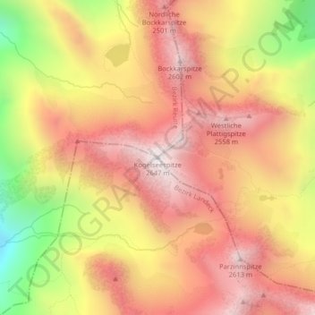
Name: Kogelseespitze topographic map, elevation, terrain.
Average elevation: 2,200 m
Minimum elevation: 1,534 m
Maximum elevation: 2,621 m
Make a donation
Gear up for your next adventure:
As an Amazon Associate, this site earns from qualifying purchases at no extra cost to you.