
Bodfish topographic map
Click on the map to display elevation.
Bodfish
Bodfish is located 32 miles (51 km) east-northeast of Bakersfield, at an elevation of 2,687 feet (819 m).
About this map
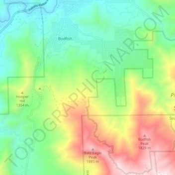
Name: Bodfish topographic map, elevation, terrain.
Location: Bodfish, Kern County, California, United States (35.53478 -118.50706 35.60295 -118.44068)
Average elevation: 1,161 m
Minimum elevation: 705 m
Maximum elevation: 1,999 m
Other topographic maps
Click on a map to view its topography, its elevation and its terrain.
Miracle Hot Springs
United States > California > Kern County > Bodfish > Miracle Hot Springs
Average elevation: 859 m