
Make a donation
Gear up for your next adventure:
As an Amazon Associate, this site earns from qualifying purchases at no extra cost to you.
Roppersthal topographic map
Click on the map to display elevation.
Make a donation
Gear up for your next adventure:
As an Amazon Associate, this site earns from qualifying purchases at no extra cost to you.
Roppersthal
Um 1449 wird der Ort erstmals unter der Bezeichnung „Ropertdaill“ in einer Liste der zu Wipperfürth gehörenden Bürgergüter genannt. Die Karte Topographia Ducatus Montani aus dem Jahre 1715 zeigt einen Hof und bezeichnet diesen mit „Rupestahl“. Die Topographische Aufnahme der Rheinlande von 1825 zeigt auf umgrenztem Hofraum unter dem Namen „Ropperzdahl“ zwei getrennt voneinander liegende Grundrisse. In der Preußischen Uraufnahme von 1840 bis 1844 verwendet man die Schreibweise „Ruppesthal“. Ab der topografischen Karte von 1894 bis 1896 wird der heute gebräuchliche Ortsname Roppersthal verwendet.
Make a donation
Gear up for your next adventure:
As an Amazon Associate, this site earns from qualifying purchases at no extra cost to you.
About this map
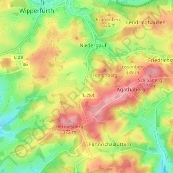
Name: Roppersthal topographic map, elevation, terrain.
Average elevation: 316 m
Minimum elevation: 252 m
Maximum elevation: 381 m
Make a donation
Gear up for your next adventure:
As an Amazon Associate, this site earns from qualifying purchases at no extra cost to you.