
Durbuy topographic map
Interactive map
Click on the map to display elevation.
About this map
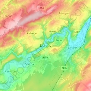
Name: Durbuy topographic map, elevation, terrain.
Location: Durbuy, Marche-en-Famenne, Luxemburg, Wallonië, 6940, België (50.31241 5.41625 50.39241 5.49625)
Average elevation: 222 m
Minimum elevation: 129 m
Maximum elevation: 343 m
Other topographic maps
Click on a map to view its topography, its elevation and its terrain.
Bende
België > Luxemburg > Marche-en-Famenne > Durbuy
Bende, Durbuy, Marche-en-Famenne, Luxemburg, Wallonië, België
Average elevation: 249 m
Heyd
België > Luxemburg > Marche-en-Famenne > Durbuy
Heyd, Durbuy, Marche-en-Famenne, Luxemburg, Wallonië, België
Average elevation: 260 m
Barvaux
België > Luxemburg > Marche-en-Famenne > Durbuy
Barvaux, Durbuy, Marche-en-Famenne, Luxemburg, Wallonië, 6940, België
Average elevation: 205 m
Bomal
België > Luxemburg > Marche-en-Famenne > Durbuy
Bomal, Durbuy, Marche-en-Famenne, Luxemburg, Wallonië, België
Average elevation: 202 m