
Guédiawaye Department topographic map
Interactive map
Click on the map to display elevation.
About this map
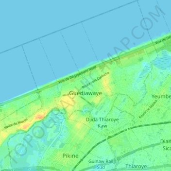
Name: Guédiawaye Department topographic map, elevation, terrain.
Location: Guédiawaye Department, Dakar Region, 15000, Senegal (14.74534 -17.43007 14.81476 -17.35960)
Average elevation: 6 m
Minimum elevation: 0 m
Maximum elevation: 28 m
Other topographic maps
Click on a map to view its topography, its elevation and its terrain.