
Thank you for supporting this site ❤️
Make a donation
Make a donation
Gear up for your next adventure:
As an Amazon Associate, this site earns from qualifying purchases at no extra cost to you.
Isivilla topographic map
Click on the map to display elevation.
Thank you for supporting this site ❤️
Make a donation
Make a donation
Gear up for your next adventure:
As an Amazon Associate, this site earns from qualifying purchases at no extra cost to you.
About this map
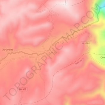
Name: Isivilla topographic map, elevation, terrain.
Location: Isivilla, Corani, Carabaya, Puno, Perú (-13.93688 -70.56286 -13.89688 -70.52286)
Average elevation: 4,393 m
Minimum elevation: 3,916 m
Maximum elevation: 4,524 m
Thank you for supporting this site ❤️
Make a donation
Make a donation
Gear up for your next adventure:
As an Amazon Associate, this site earns from qualifying purchases at no extra cost to you.