
Fairfield Glade topographic map
Interactive map
Click on the map to display elevation.
About this map
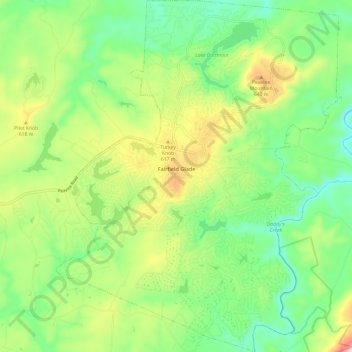
Name: Fairfield Glade topographic map, elevation, terrain.
Average elevation: 542 m
Minimum elevation: 425 m
Maximum elevation: 761 m
Other topographic maps
Click on a map to view its topography, its elevation and its terrain.
Crossville
United States > Tennessee > Cumberland County
Crossville, Cumberland County, East Tennessee, Tennessee, United States
Average elevation: 553 m
Pleasant Hill
United States > Tennessee > Cumberland County
Pleasant Hill, Cumberland County, East Tennessee, Tennessee, 38578, United States
Average elevation: 563 m
Meadowview
United States > Tennessee > Cumberland County > Crossville
Meadowview, Crossville, Cumberland County, East Tennessee, Tennessee, 37855, United States
Average elevation: 553 m
Port Haven
United States > Tennessee > Cumberland County > Crossville
Port Haven, Crossville, Cumberland County, Tennessee, 59300, United States
Average elevation: 549 m
Deerwood
United States > Tennessee > Cumberland County
Deerwood, Cumberland County, Tennessee, United States
Average elevation: 449 m
Genesis
United States > Tennessee > Cumberland County
Genesis, Cumberland County, Tennessee, United States
Average elevation: 509 m
Lantana
United States > Tennessee > Cumberland County
Lantana, Cumberland County, Tennessee, 38572, United States
Average elevation: 583 m
Humptulips
United States > Tennessee > Cumberland County
Humptulips, Cumberland County, East Tennessee, Tennessee, United States
Average elevation: 561 m
Hiawatha Subdivision
United States > Tennessee > Cumberland County
Hiawatha Subdivision, Cumberland County, Tennessee, 38557, United States
Average elevation: 571 m
Lake Pomeroy
United States > Tennessee > Cumberland County > Fairfield Glade
Lake Pomeroy, Fairfield Glade, Cumberland County, Tennessee, 38558, United States
Average elevation: 522 m
Ozone
United States > Tennessee > Cumberland County > Ozone
Ozone, Cumberland County, Tennessee, United States
Average elevation: 502 m
Crossville
United States > Tennessee > Cumberland County > Crossville
Crossville, Cumberland County, Tennessee, 37855, United States
Average elevation: 555 m
Maplewood Estates
United States > Tennessee > Cumberland County > Crossville > Maplewood Estates
Maplewood Estates, Crossville, Cumberland County, Tennessee, 37855, United States
Average elevation: 553 m
Crab Orchard
United States > Tennessee > Cumberland County > Crab Orchard > Crab Orchard
Crab Orchard, Cumberland County, Tennessee, 37723, United States
Average elevation: 584 m