Geolocate

Ruscio topographic map

Click on the map to display elevation.

About this map

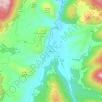
Name: Ruscio topographic map, elevation, terrain.

Location: Ruscio, Monteleone di Spoleto, Perugia, Umbria, 06045, Italy (42.62463 12.93749 42.66463 12.97749)

Average elevation: 902 m

Minimum elevation: 743 m

Maximum elevation: 1,260 m

Gear up for your next adventure:

🧴Sunscreen SPF - Broad-spectrum sunscreen for outdoor activities
🔭Compact Monocular - One-handed bird watching and trail spotting
🔥Emergency Fire Starter - Reliable ignition source for all weather conditions
Bushcraft Tarp - Versatile emergency shelter or gear protection
🥾Mountain Trail Shoes - High-traction shoes for mountain trails

As an Amazon Associate, this site earns from qualifying purchases at no extra cost to you.