
Make a donation
Gear up for your next adventure:
As an Amazon Associate, this site earns from qualifying purchases at no extra cost to you.
Laiz topographic map
Click on the map to display elevation.
Make a donation
Gear up for your next adventure:
As an Amazon Associate, this site earns from qualifying purchases at no extra cost to you.
About this map
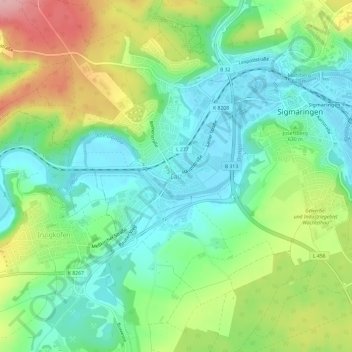
Name: Laiz topographic map, elevation, terrain.
Average elevation: 624 m
Minimum elevation: 569 m
Maximum elevation: 727 m
Make a donation
Gear up for your next adventure:
As an Amazon Associate, this site earns from qualifying purchases at no extra cost to you.
Other topographic maps
Click on a map to view its topography, its elevation and its terrain.
Oberschmeien
Deutschland > Baden-Württemberg > Landkreis Sigmaringen > Sigmaringen
Oberschmeien liegt im Tal der namensgebenden Schmeie – der Ortskern zieht sich am linken Hangfuß entlang – im Naturpark Obere Donau. Am Hang darüber findet sich ein Neubaugebiet. Der Aussichtspunkt Fürstenhöhe bietet bei klarem Wetter einen Blick über Oberschwaben hinweg bis zu den Alpen. Auf der…
Average elevation: 712 m
72488
Deutschland > Baden-Württemberg > Landkreis Sigmaringen > Sigmaringen > Laiz
Average elevation: 652 m
Gutenstein
Deutschland > Baden-Württemberg > Landkreis Sigmaringen > Sigmaringen
Average elevation: 677 m
Gutenstein
Deutschland > Baden-Württemberg > Landkreis Sigmaringen > Sigmaringen
Average elevation: 677 m
Make a donation
Gear up for your next adventure:
As an Amazon Associate, this site earns from qualifying purchases at no extra cost to you.