
Thank you for supporting this site ❤️
Make a donation
Make a donation
Gear up for your next adventure:
As an Amazon Associate, this site earns from qualifying purchases at no extra cost to you.
Agururu B I 'e' topographic map
Click on the map to display elevation.
Thank you for supporting this site ❤️
Make a donation
Make a donation
Gear up for your next adventure:
As an Amazon Associate, this site earns from qualifying purchases at no extra cost to you.
About this map
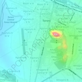
Name: Agururu B I 'e' topographic map, elevation, terrain.
Location: Agururu B I 'e', Tororo, Uganda (0.66184 34.15634 0.70184 34.19634)
Average elevation: 1,191 m
Minimum elevation: 1,138 m
Maximum elevation: 1,459 m
Thank you for supporting this site ❤️
Make a donation
Make a donation
Gear up for your next adventure:
As an Amazon Associate, this site earns from qualifying purchases at no extra cost to you.