
Make a donation
Gear up for your next adventure:
As an Amazon Associate, this site earns from qualifying purchases at no extra cost to you.
Touro topographic map
Click on the map to display elevation.
Make a donation
Gear up for your next adventure:
As an Amazon Associate, this site earns from qualifying purchases at no extra cost to you.
Touro
Para hacer un estudio completo de la climatología del ayuntamiento de Touro, se toman datos de la estación meteorológica situada en el aeropuerto de Lavacolla (Altitud(m):364 Latitud: 42 53 58 Longitud: 8 25 37), que es la más cercana al ayuntamiento y con características geográficas parecidas. Los datos pertenecen la un período largo, que va desde 1977 al 2004, para que el estudio sea más completo y fiable.
Make a donation
Gear up for your next adventure:
As an Amazon Associate, this site earns from qualifying purchases at no extra cost to you.
About this map
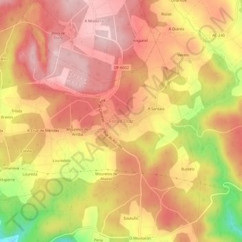
Name: Touro topographic map, elevation, terrain.
Location: Touro, Arzúa, La Coruña, Galicia, 15822, España (42.84720 -8.32381 42.88720 -8.28381)
Average elevation: 299 m
Minimum elevation: 139 m
Maximum elevation: 383 m
Make a donation
Gear up for your next adventure:
As an Amazon Associate, this site earns from qualifying purchases at no extra cost to you.