
Make a donation
Gear up for your next adventure:
As an Amazon Associate, this site earns from qualifying purchases at no extra cost to you.
Cerro Chiricayén topographic map
Click on the map to display elevation.
Make a donation
Gear up for your next adventure:
As an Amazon Associate, this site earns from qualifying purchases at no extra cost to you.
About this map
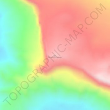
Name: Cerro Chiricayén topographic map, elevation, terrain.
Average elevation: 1,249 m
Minimum elevation: 1,007 m
Maximum elevation: 1,450 m
Make a donation
Gear up for your next adventure:
As an Amazon Associate, this site earns from qualifying purchases at no extra cost to you.
Other topographic maps
Click on a map to view its topography, its elevation and its terrain.
Auyantepuy
Venezuela > Estado Bolívar > Municipio Gran Sabana
El Auyantepuy es un gigante entre las mesetas grandes. Tiene una altitud de 2535 metros y una superficie de unas 70.500 hectáreas o 705 kilómetros cuadrados, lo que quiere decir que tiene una superficie comparable a la de países como Singapur o es mucho más extenso que naciones como Andorra. Desde su cima…
Average elevation: 1,203 m
Make a donation
Gear up for your next adventure:
As an Amazon Associate, this site earns from qualifying purchases at no extra cost to you.
Laguna de Canaima
Venezuela > Estado Bolívar > Municipio Gran Sabana > Canaima
Average elevation: 414 m
Make a donation
Gear up for your next adventure:
As an Amazon Associate, this site earns from qualifying purchases at no extra cost to you.