Geolocate

Pierrefitte-Nestalas topographic map

Click on the map to display elevation.

About this map

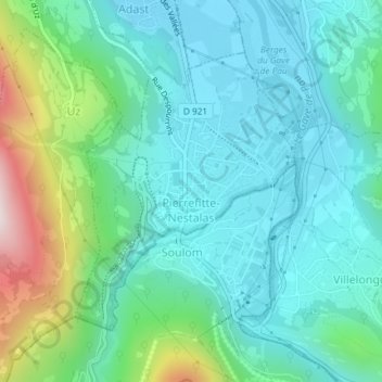
Name: Pierrefitte-Nestalas topographic map, elevation, terrain.

Location: Pierrefitte-Nestalas, Argelès-Gazost, Hautes Pyrenees, Occitania, Metropolitan France, 65260, France (42.95081 -0.08516 42.97049 -0.06338)

Average elevation: 601 m

Minimum elevation: 444 m

Maximum elevation: 1,136 m

Other topographic maps

Click on a map to view its topography, its elevation and its terrain.

Le Plan

France > Occitania > Hautes Pyrenees > Aragnouet > Le Plan

Average elevation: 1,810 m

Eget Village

France > Occitania > Hautes Pyrenees > Aragnouet > Eget Village

Average elevation: 1,560 m

Gear up for your next adventure:

Lightweight Backpacking Tent - Compact tent for efficient hiking trips
🪜Heavy Duty Carabiners - Multi-use clips for securing gear to your backpack
🥾Waterproof Hiking Boots - Boots keeping your feet dry in wet conditions
🛰️Satellite Messenger - Emergency communication for areas with no cell service
🛶Kayak Accessories - Essential gear for safe and fun kayaking adventures

As an Amazon Associate, this site earns from qualifying purchases at no extra cost to you.