Geolocate

Bayard topographic map

Click on the map to display elevation.

About this map

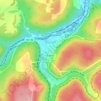
Name: Bayard topographic map, elevation, terrain.

Location: Bayard, Grant County, West Virginia, United States (39.26530 -79.37257 39.27597 -79.35781)

Average elevation: 793 m

Minimum elevation: 707 m

Maximum elevation: 889 m

Other topographic maps

Click on a map to view its topography, its elevation and its terrain.

Mount Storm

United States > West Virginia > Grant County

Average elevation: 834 m

Mount Storm

United States > West Virginia > Grant County

Average elevation: 834 m

Gear up for your next adventure:

🎒Hiking Backpack - Lightweight and ergonomic backpacks for day hikes or multi-day treks
🔨Vehicle Emergency Tool - Safety tool for remote road trips to trailheads
🧴Insect Repellent - Protect yourself from bugs during outdoor adventures
Camping Groundsheet - Protect your tent from moisture and dirt
🧢Sun Protection Cap - Breathable cap to protect from sun exposure

As an Amazon Associate, this site earns from qualifying purchases at no extra cost to you.