
The Municipal District of Wicklow topographic map
Interactive map
Click on the map to display elevation.
About this map
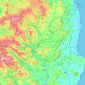
Name: The Municipal District of Wicklow topographic map, elevation, terrain.
Average elevation: 263 m
Minimum elevation: -1 m
Maximum elevation: 925 m
Other topographic maps
Click on a map to view its topography, its elevation and its terrain.
Enniskerry
Enniskerry, County Wicklow, Leinster, Irlande
Average elevation: 111 m
Cornan West
Cornan West, Rathdangan ED, The Municipal District of Baltinglass, County Wicklow, Leinster, Irlande
Average elevation: 258 m
Glendalough
Glendalough, The Municipal District of Wicklow, County Wicklow, Leinster, A98 VY72, Irlande
Average elevation: 284 m
Blessington
Blessington, County Wicklow, Leinster, Irlande
Average elevation: 205 m
Enniskerry
Enniskerry, Enniskerry ED, The Municipal District of Bray, County Wicklow, Leinster, Irlande
Average elevation: 104 m
Blessington
Irlande > County Wicklow > Blessington
Blessington, The Municipal District of Baltinglass, County Wicklow, Leinster, W91 AC86, Irlande
Average elevation: 223 m