
Make a donation
Gear up for your next adventure:
As an Amazon Associate, this site earns from qualifying purchases at no extra cost to you.
Cassville topographic map
Click on the map to display elevation.
Make a donation
Gear up for your next adventure:
As an Amazon Associate, this site earns from qualifying purchases at no extra cost to you.
Cassville
Cassville is located in south-central Huntingdon County at 40°17′35″N 78°1′40″W / 40.29306°N 78.02778°W / 40.29306; -78.02778 (40.293042, -78.027646), at an elevation of 1,241 feet (378 m). It sits at the western base of Sideling Hill, which rises 400 feet (120 m) above the borough. Shirley Knob rises 600 feet (180 m) above the borough to the southwest.
Make a donation
Gear up for your next adventure:
As an Amazon Associate, this site earns from qualifying purchases at no extra cost to you.
About this map
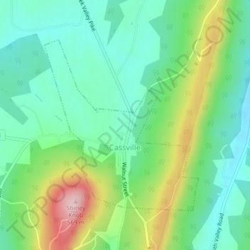
Name: Cassville topographic map, elevation, terrain.
Average elevation: 399 m
Minimum elevation: 323 m
Maximum elevation: 563 m
Make a donation
Gear up for your next adventure:
As an Amazon Associate, this site earns from qualifying purchases at no extra cost to you.
Other topographic maps
Click on a map to view its topography, its elevation and its terrain.
Warriors Mark
United States > Pennsylvania > Huntingdon County > Warriors Mark Township
Average elevation: 370 m
Make a donation
Gear up for your next adventure:
As an Amazon Associate, this site earns from qualifying purchases at no extra cost to you.
Spruce Creek
United States > Pennsylvania > Huntingdon County > Spruce Creek Township
Average elevation: 329 m
Puttstown
United States > Pennsylvania > Huntingdon County > Hopewell Township
Average elevation: 330 m
Make a donation
Gear up for your next adventure:
As an Amazon Associate, this site earns from qualifying purchases at no extra cost to you.
Pennsylvania Furnace
United States > Pennsylvania > Huntingdon County > Franklin Township
Average elevation: 363 m
McAlevys Fort
United States > Pennsylvania > Huntingdon County > Jackson Township
Average elevation: 265 m
Make a donation
Gear up for your next adventure:
As an Amazon Associate, this site earns from qualifying purchases at no extra cost to you.
McConnellstown
United States > Pennsylvania > Huntingdon County > Walker Township
Average elevation: 257 m
Make a donation
Gear up for your next adventure:
As an Amazon Associate, this site earns from qualifying purchases at no extra cost to you.
Blairs Mills
United States > Pennsylvania > Huntingdon County > Tell Township
Average elevation: 283 m
Lake Jeanette
United States > Pennsylvania > Huntingdon County > Jackson Township
Average elevation: 268 m
Water Street
United States > Pennsylvania > Huntingdon County > Morris Township
Average elevation: 319 m
Make a donation
Gear up for your next adventure:
As an Amazon Associate, this site earns from qualifying purchases at no extra cost to you.