Geolocate

Satyamangalam topographic map

Click on the map to display elevation.

Satyamangalam

Sathyamangalam is situated on the southern side of the Western Ghats, which extend towards the east from the Nilgiri mountains. The general topography is not flat and covered by sloping lands. Bhavani river flows at the center of the town from west to east. Agricultural wet lands are predominant on both sides of the river and dry lands are predominant on the northern side of the town. The soil mainly consists of black loam, red loam and red sand.

Wikipedia (CC-BY-SA 3.0)

About this map

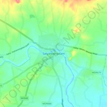
Name: Satyamangalam topographic map, elevation, terrain.

Location: Satyamangalam, Sathyamangalam, Erode District, Tamil Nadu, 638401, India (11.46108 77.20514 11.54108 77.28514)

Average elevation: 248 m

Minimum elevation: 224 m

Maximum elevation: 310 m

Other topographic maps

Click on a map to view its topography, its elevation and its terrain.

Perumpallam dam

India > Tamil Nadu > Sathyamangalam

Average elevation: 335 m

Bhavanisagar Lake

India > Tamil Nadu > Sathyamangalam > Pungar

Average elevation: 349 m

Gear up for your next adventure:

🌬️Windproof Camp Stove - Efficient cooking even on exposed mountain peaks
🧰Multitool Knife - Compact and versatile tool for outdoor use
🕯️Camping Lantern - Illuminates your entire campsite with high-efficiency LEDs
🧦Thermal Socks - Warm socks for winter hiking or camping
🥾Mountain Hiking Boots - High-traction boots for rocky terrain

As an Amazon Associate, this site earns from qualifying purchases at no extra cost to you.