
Make a donation
Gear up for your next adventure:
As an Amazon Associate, this site earns from qualifying purchases at no extra cost to you.
Marlin topographic map
Click on the map to display elevation.
Make a donation
Gear up for your next adventure:
As an Amazon Associate, this site earns from qualifying purchases at no extra cost to you.
About this map
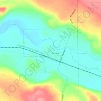
Name: Marlin topographic map, elevation, terrain.
Location: Marlin, Grant County, Washington, United States (47.40325 -119.00023 47.41487 -118.97849)
Average elevation: 430 m
Minimum elevation: 391 m
Maximum elevation: 496 m
Make a donation
Gear up for your next adventure:
As an Amazon Associate, this site earns from qualifying purchases at no extra cost to you.
Other topographic maps
Click on a map to view its topography, its elevation and its terrain.
Make a donation
Gear up for your next adventure:
As an Amazon Associate, this site earns from qualifying purchases at no extra cost to you.
Moses Lake
United States > Washington > Grant County > Moses Lake > Moses Lake
Average elevation: 342 m