Geolocate

Puray topographic map

Click on the map to display elevation.

About this map

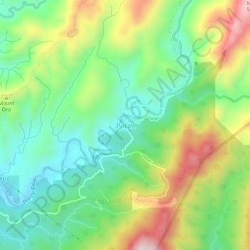
Name: Puray topographic map, elevation, terrain.

Location: Puray, Montalban, Rizal, Calabarzon, 1860, Philippines (14.75194 121.18447 14.79194 121.22447)

Average elevation: 248 m

Minimum elevation: 57 m

Maximum elevation: 575 m

Other topographic maps

Click on a map to view its topography, its elevation and its terrain.

Wawa Dam

Philippines > Rizal > Montalban > Wawa > Inigan

Average elevation: 156 m

Gear up for your next adventure:

🧥Thermal Layer - Insulating layer for cold outdoor conditions
Camping Tent - Weather-resistant tents suitable for 2 to 6 people
🧼Biodegradable Camp Soap - Environmentally friendly cleaning for gear and body
💧Hydration Pack - Hands-free hydration system for long hikes
🧴Bear Spray Holster - Quick-access carry for essential Canadian wilderness safety

As an Amazon Associate, this site earns from qualifying purchases at no extra cost to you.