
Make a donation
Gear up for your next adventure:
As an Amazon Associate, this site earns from qualifying purchases at no extra cost to you.
Bailén topographic map
Click on the map to display elevation.
Make a donation
Gear up for your next adventure:
As an Amazon Associate, this site earns from qualifying purchases at no extra cost to you.
About this map
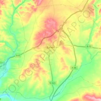
Name: Bailén topographic map, elevation, terrain.
Location: Bailén, Jaén, Andalusia, 23710, Spain (38.03151 -3.86786 38.15380 -3.70639)
Average elevation: 329 m
Minimum elevation: 218 m
Maximum elevation: 482 m
Make a donation
Gear up for your next adventure:
As an Amazon Associate, this site earns from qualifying purchases at no extra cost to you.
Other topographic maps
Click on a map to view its topography, its elevation and its terrain.
Piedra del Águila
Spain > Andalusia > Comarca de Huéscar > Puebla de Don Fadrique
Average elevation: 1,295 m
Cerro de Fabián
Spain > Andalusia > Sierra de Cádiz > Villaluenga del Rosario
Average elevation: 736 m
Make a donation
Gear up for your next adventure:
As an Amazon Associate, this site earns from qualifying purchases at no extra cost to you.